Disclosure: Some links in this post are affiliate links. As an Amazon Associate I earn from qualifying purchases, at no extra cost to you. Learn more
Specs are compiled from manufacturer listings and verified buyer reviews and can change over time — please confirm the key details on the product page before buying.
You need a device that still knows where you are when the pavement turns to two-track and your phone drops to one bar of signal. A dedicated receiver has to do exactly that. A good overlanding unit locks onto satellites without cell service, survives dust and rain, and runs long enough for a multi-day route. This guide ranks the contenders by satellite lock, battery runtime and glove-friendly controls in the backcountry.
This guide is built by comparing the manufacturers’ published specifications and the patterns across verified customer reviews, so you get each pick’s real strengths and trade-offs instead of marketing spin.
You can carry a pocket-sized trail companion or bolt a big screen to your dash. That choice drives battery life, screen size and how you mount it. This breakdown of the gps for overlanding covers both styles and the specs that actually matter off the grid.
Top Picks


How To Choose The Best GPS for Overlanding
Overlanding is a different job from a weekend hike. You are covering long distances across mixed terrain, often with no cell signal, and you need the device to keep working when the weather turns sour. The specs below are the ones that separate a real trail navigator from a car unit pressed into duty.
Satellite networks: how many your unit listens to
Multi-GNSS means the receiver tracks more than one satellite network at the same time — typically GPS, GLONASS and Galileo. More networks means more satellites to draw from, so the unit holds a fix in tight canyons and under dense canopy where a single-network device stalls. Look for a unit that names the networks it supports rather than just saying “GPS.”
Battery: hours on paper versus hours on the trail
A spec sheet that lists 16 hours in GPS mode is a starting point, not a promise. Screen brightness, map detail and how long you keep the backlight on all eat into that number. Expedition mode is the other figure to watch — it trades frequent position updates for a much longer run, which is what carries you through a multi-day stretch without a charge.
Screen versus buttons: pick for gloves and daylight
Touchscreens are faster to pan a map and read bigger. Physical buttons work through gloves and in the rain without fussing. A sunlight-readable display matters more than raw size — a bright 3-inch panel you can read in full sun beats a dim larger one. Glove-friendly touch panels try to bridge the gap, but they still struggle with wet, muddy hands.
Maps: preloaded, expandable, and routable
Preloaded topo maps get you started, but check they cover routable roads and trails, not just a static picture. A microSD slot lets you add regional maps later without buying a new unit. If you ride far from home, expandable map storage is worth more than a slightly larger screen.
Side-by-Side Comparison
| Model | Best For | Battery Life (GPS mode) | Display | Multi-GNSS | Amazon |
|---|---|---|---|---|---|
| Garmin GPSMAP 64sx★ Best Overall | Budget trail handheld | Up to 16 hours | 2.6″ sunlight-readable color | GPS, GLONASS, Galileo | Amazon |
| Garmin GPSMAP 67Longest Runtime | Long-range handheld | Up to 182 hours / 840 in expedition | 3″ sunlight-readable color | Expanded GNSS, multi-band | Amazon |
| Garmin dezl OTR610Big Screen Pick | Big-screen mounted routing | — | 6″ HD color touch | — | Amazon |
| Garmin Montana 700 | Large handheld touchscreen | 18 hours | 5″ glove-friendly touch | GPS, GLONASS, Galileo | Amazon |
| Garmin dezlCam OTR710 | Navigator with dash cam | — | 7″ color touch | — | Amazon |
| Garmin Montana 710 | Premium 5″ handheld | 24 hours / 432 in expedition | 5″ glove-friendly touch | Multi-GNSS, ABC sensors | Amazon |
| Garmin dezl OTR1010 | Extra-large dash screen | — | 10″ color touch | — | Amazon |
| Garmin Tread | Group-ride off-road | 6 hours | 5.5″ ultrabright touch | Built-in ABC sensors | Amazon |
| Garmin dezl OTR1020 Bundle | Premium bundle deal | — | 10″ extra-large touch | — | Amazon |
Detailed Reviews
1. Garmin GPSMAP 64sx
Our pick — 4.5+★ from 900+ verified ratings; the strongest balance of quality and price.
The button-operated trail unit that survives a glove box and still reads in direct sun.
If you want the cheapest way into a genuine Garmin trail handheld, start here. The GPSMAP 64sx runs up to 16 hours in GPS mode on standard batteries, which means you can swap in fresh cells at camp instead of hunting an outlet. It carries a high-sensitivity receiver with a quad helix antenna — a spiral antenna that grabs a signal from more angles — plus multi-GNSS support across GPS, GLONASS and Galileo. That combination is what keeps a fix locked in when you are walled in by terrain.
Battery runtime is where it shows its age against the fancier units. Compared to the GPSMAP 67 and its 182 hours, the 64sx offers 16 hours — a gap you feel on a long route without a power bank. Buyers report the workaround in plain terms: using GPS-only mode at 50% brightness stretches the alkaline cells to the 14-16 hour range, and lithium batteries last longer still. That is honest battery management, not a defect.
The interface earns mixed reactions. Some find it excellent and quick to learn; others call it not intuitive. One owner’s gripe was missing a single home screen that shows coordinates in two formats, time and date together. Plan for a few days of practice before a trip. The 2.6-inch sunlight-readable color display stays visible in full sun, and button control works through gloves and rain where a touchscreen would fight you.
What holds up on the trail
- Preloaded TopoActive maps with routable roads and trails for cycling and hiking.
- Quad helix antenna with GPS, GLONASS and Galileo support for a steady fix in tight terrain.
- 3-axis compass and barometric altimeter give you heading and elevation without a separate tool.
- Standard batteries mean you can carry spares and refuel anywhere.
Where it asks patience
- 16 hours in GPS mode is short next to the 182-hour GPSMAP 67.
- The menu layout is mixed — expect a learning curve before it feels natural.
- TopoActive coverage is U.S. and Australia only from the start.
Reach for this if: you want proven trail navigation on a tight budget and do not mind carrying spare batteries.
Think twice if: your routes run several days between charges — the 67 is the better fit there.
2. Garmin GPSMAP® 67, Rugged GPS Handheld
A rechargeable handheld that runs for days, not hours, between charges.
The number that defines this unit is 182 hours of battery life in standard mode, and up to 840 hours in expedition mode. Set that against the GPSMAP 64sx at 16 hours and the difference is huge — this is the one you take on a week-long route without a solar panel. It runs on an internal lithium-ion battery you top up over USB-C, and the multi-band GNSS technology pulls enhanced accuracy in steep country, urban canyons and forests with dense trees.
Owners describe a receiver that acquires satellites fast, even indoors near a window, and holds a lock in dense forests and remote areas. The 3-inch sunlight-readable color display is brighter than the older 66, and the side-mounted microSD slot makes map swaps easy. Preloaded detailed maps come included, and added maps go on the card. An altimeter, barometer and 3-axis compass round out the mountain kit.
Where it will test you is the interface. The menu depth is real, and beginners find it less friendly than a phone app — a learning curve several owners point to. That trade-off is deliberate: it is a navigation tool, not a smartwatch or tablet replacement, and that focus is why it stays reliable. Budget-conscious shoppers also skip the 67i variant to avoid a monthly fee.
Runtime headline: 182 hours standard and 840 in expedition mode is the reason this sits near the top for overlanding.
The caveat worth knowing: expect to spend a few sessions learning the menus before your first big trip.
Go this way when: the trail runs long and charging is scarce — the battery math wins outright.
Skip if: you want smartphone-simple controls from the start.
3. Garmin dezl OTR610, 6″ GPS Truck Navigator
A 6-inch dash navigator that routes around low bridges and steep grades.
Build a rig with a high roof or a long wheelbase and this is the unit that accounts for it. The OTR610 takes your vehicle’s size and weight and builds custom routing around bridge heights, weight limits, sharp curves and steep grades. Its 6-inch touchscreen is bright and crisp, and the packaging is compact at 6″L x 0.7″W x 3.4″H and 6.17 ounces. Weigh that against the GPSMAP 67 at 8.1 ounces — the bigger screen unit is the lighter one here.
What wins people over is the arrival planning. BirdsEye Satellite Imagery gives you high-resolution aerial views of loading docks, truck entrances and security gates, which matters when you are pulling a heavy rig into an unfamiliar yard. The route planner helps map fuel stops, breaks and overnight stays. Truck stop filtering and PrePass weigh-station notifications tie it into the parked-in-the-cab workflow.
Be honest about the fit: this is a road navigator, not a trail unit. Address entry defaults to the same city, and state selection takes some getting used to. A few drivers find it occasionally tells them they are going the wrong way, and the routing is only as good as the profile you type in. For off-grid trail work a handheld wins, but for the highway legs between trailheads the 6-inch display and driver alerts are hard to argue with.
Why it earns a spot: custom routing for height and weight plus BirdsEye dock views solve a real overlanding problem with a loaded rig.
Fit note: the interface assumes a highway driver’s workflow, so backcountry trail navigation is not its strength.
Best matched to: overlanders crossing long highway stretches in a tall or heavy rig.
Move on if: most of your route is unmarked two-track — grab a handheld instead.
4. Garmin Montana 700, Rugged GPS Handheld

A 5-inch touchscreen handheld built to shrug off heat, shock and water.
The Montana 700 is where a phone-sized screen meets a tank of a body. Its 5-inch glove-friendly touchscreen is 50% larger than the previous model, which makes waypoints and trail junctions readable without squinting. Rugged construction is rated to MIL-STD 810 for thermal, shock, water and vibration — that is a military-style benchmark for surviving drops and temperature swings. Overlanding on washboard roads is exactly the abuse it is built for.
Battery life is 18 hours, and multi-GNSS support covers GPS, GLONASS and Galileo with preloaded TopoActive maps. The outdoor sensor set includes a 3-axis compass and barometric altimeter. Wi-Fi, Bluetooth and ANT+ let the unit pull BirdsEye Satellite Imagery directly and share locations, while the Garmin Explore app manages waypoints and tracks. Owners also like that a AA battery adapter works as a backup — handy when the lithium pack runs low far from a charger.
This is the older, more affordable sibling to the Montana 710, and the differences show. Owners describe the bigger 5-inch screen as a real step up in readability and the grip as improved. The honest caveat: some hunters find the preloaded topo maps short on contour detail, so check map detail against your terrain before committing. Street map and app pairing can also take fiddling.
Trail-ready strengths
- 5″ glove-friendly touchscreen (50% larger than the prior model) for at-a-glance reading.
- MIL-STD 810 rating for thermal, shock, water and vibration.
- Multi-GNSS plus preloaded TopoActive maps and BirdsEye imagery over Wi-Fi.
- AA battery adapter gives you a backup power path.
Where it falls short
- 18-hour battery life trails the 24-hour Montana 710.
- Some find the preloaded topo contour detail thin for backcountry hunting.
- Street-map and app pairing can need extra setup effort.
Worth it for: the overlander who wants a big touchscreen and near-indestructible build without premium pricing.
Look elsewhere if: you need the longest possible runtime or finer backcountry topo detail.
5. Garmin dēzlCam OTR710

One screen that routes your rig and records the road ahead at the same time.
If you want to consolidate gear, this is the two-in-one of the group. The OTR710 pairs a 7-inch bright high-resolution touchscreen with a built-in dash cam that records HD video and saves incident clips automatically. Those clips land securely in an online Vault you reach through the dēzl app. On top of routing, forward collision and lane departure warnings nudge you when you drift — handy at the end of a long haul.
The navigation side carries the same custom routing for vehicle size and weight, with bridge-height, weight-limit and steep-grade alerts. BirdsEye Satellite Imagery shows the loading dock before you arrive, and the route planner maps fuel stops and overnight stays. It includes a pre-installed 16GB microSD card, which is a sensible touch. The 7-inch size sits between the compact 6-inch dezl and the huge 10-inch models.
Expect a few quirks. Satellite imagery needs a per-location Wi-Fi download, so plan around connectivity, and some report the unit occasionally needs a power-button hold to wake. The camera alerts can feel noisy on open highway. Owners still rate the wide camera view and easy setup highly, and it works as a daily driver.
Two tools, one mount: the built-in HD dash cam plus collision warnings means less clutter on your windshield.
Get ready to manage it: imagery downloads and the occasional wake-up quirk mean a little housekeeping between trips.
Ideal for: drivers who want route guidance and incident recording from a single 7-inch unit.
Not the pick if: you would rather keep navigation and camera as separate, simpler devices.
6. Garmin Montana® 710, GPS Handheld Navigator
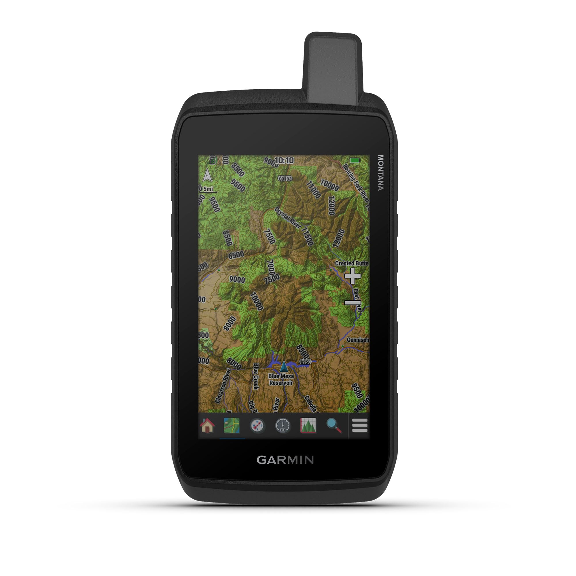
The 5-inch trail handheld with enough memory and battery for the long haul.
The Montana 710 is the handheld for the overlander who wants a big, glove-friendly 5-inch touchscreen and real endurance. It runs up to 24 hours in GPS mode and up to 432 hours in expedition mode on its rechargeable lithium-ion pack. Set that against the Montana 700 at 18 hours and you see the newer unit’s edge. It also stores more, with expanded 32 GB memory for added maps — City Navigator for streets or BlueChart g3 charts for water, sold separately.
Rugged construction is rated to MIL-STD 810 for thermal, shock and vibration, plus IPX7 for water-resistance — IPX7 means it survives a dunk in water. Built-in ABC sensors cover an altimeter for elevation, a barometer to watch weather and a 3-axis electronic compass. Downloadable high-resolution satellite imagery lets you drop waypoints on landmarks. Owners like the touchscreen for panning maps faster and more precisely than a button cursor, and the large display is readable in all conditions.
The catch is map management. Several owners note that handheld-installed maps cannot be deleted without a computer and the Basecamp software, so expect a desktop step for big map changes. Brightness control has also drawn scattered gripes, with the automatic dimming dividing opinion. Plan to mount it on a RAM-style cradle for ATV or dash duty, since the mounting options are sold separately.
The draw: 24 hours in GPS mode, 432 in expedition, and 32 GB for maps make this the most self-sufficient handheld here.
An honest wrinkle: managing and removing maps takes a computer and Basecamp, which slows down big map swaps.
Pick this when: you want a large touchscreen handheld with day-after-day battery and room for regional maps.
Consider a pass if: you want to manage maps entirely from the device.
7. Garmin dēzl™ OTR1010, 10″ GPS Truck Navigator

A tablet-sized navigator you read at a glance from the driver’s seat.
At 10 inches, this screen changes how you navigate. The OTR1010 offers an extra-large touchscreen in landscape or portrait view, bright and crisp enough to read in a hurry. Owners compare it to an iPad in scale. The split-screen view shows your remaining route beside impending wind and weather conditions, so a gust front does not surprise you mid-drive. It weighs 1.2 pounds — a real piece of equipment, not a phone mount.
The routing suite is what you expect from the dezl line: custom truck routing around height, weight, curves and grades, BirdsEye dock imagery, a route planner and truck-stop filtering by brand or amenity. PrePass weigh-station notifications are there for the highway legs. Live traffic, weather and loyalty points at Love’s and Pilot flow through the dēzl app over Bluetooth, and the magnetic powered mount lets you snap the screen off to hold it.
The honest part: this is a road-first navigator. Drivers find it very accurate and praise the guidance, but a few note it can flag a road as closed when it is actually open, so keep your judgment on. The giant screen is also more to mount and manage. For a multi-day overland run along highways with a heavy trailer, the 10-inch readability and live wind and weather alerts earn their place.
Why the big screen wins
- 10″ touchscreen in landscape or portrait with split-screen route and weather.
- Custom truck routing plus BirdsEye aerial views of loading docks.
- Magnetic powered mount makes it easy to remove and remount.
- Live traffic, weather and fuel-stop rewards through the dēzl app.
What to weigh
- Road routing flagged as closed roads occasionally being open.
- 1.2 pounds and a big footprint take real dash space.
- Backcountry trail detail is not its focus.
Great for: highway-heavy overland routes where an at-a-glance giant display and live weather matter most.
Less suited to: tight-cab builds or trail-first trips where a compact handheld fits better.
8. Garmin Tread

The off-road unit that keeps a whole convoy on one map and on the radio.
Riding solo is one thing; keeping a group together off-grid is another. The Tread handles the second. Its Group Ride Radio with push-to-talk fist mic and group tracking keeps up to 20 riders on one map, so nobody wanders off the trail. The 5.5-inch ultrabright glove-friendly touchscreen is IPX7 weather-resistant, meaning it survives a soaking. Preloaded topographic and street maps of North America include public land boundaries, U.S. Forest Service roads and Motor Vehicle Use Maps.
The off-road toolkit goes deeper than maps. Built-in altimeter, barometer, compass, gyroscope and pitch-and-roll gauges help you read challenging terrain. You can pair compatible inReach satellite communicators for two-way messaging and interactive SOS, though that needs a separate subscription. The Tread app syncs waypoints, tracks and routes and handles GPX import and export. The powered mount and tube-mount wiring secure it to an ATV, UTV or snowmobile.
Battery life is 6 hours, so this is a wired-in unit, not a battery-first handheld — that is the trade-off for the radio and gauges. A few riders find the push-to-talk button awkward on a motorcycle, and it leans UTV-oriented. Map detail for some regions can also be thin from the start. Owners on group rides and cold-weather snowmobile trips rate it highly.
The group advantage: tracking and push-to-talk for up to 20 riders plus pitch-and-roll gauges make this a convoy tool, not a solo navigator.
Wired in, not wandering: 6 hours of battery means you mount it to vehicle power, and the PTT button suits UTVs better than bikes.
Made for: UTV, ATV and snowmobile groups who want shared tracking and radio contact off-grid.
Not for: solo hikers or anyone wanting a pocketable, battery-first device.
9. Garmin dēzl OTR1020 GPS Truck Navigator 10″ Bundle

A 10-inch navigator bundle that arrives with the memory card and cleaning kit.
This bundle takes the OTR1020’s 10-inch extra-large high-resolution touchscreen and adds a Sandisk 32GB microSD card plus a screen cleaning kit in the box. The screen is built for clarity on a long haul, and the high resolution makes route detail easy to see at a glance. It comes with community-driven insights where drivers rate parking, loading docks and truck-friendly stops, so you build a picture of where to stop before you get there.
The navigation suite includes real-time alerts for sharp curves, steep grades and speed changes, plus PrePass weigh-station and bypass notifications. Wind speed weather alerts add hazard info for the route ahead. The dēzl app brings hands-free calling, smart notifications and live traffic and weather, and built-in Wi-Fi keeps maps and software current without a computer. Custom truck routing accounts for height, weight and hazardous materials.
The standing caveat is the same one that runs through the dezl line: it is a highway tool first. Reaching the full feature set also wants a newer phone and Wi-Fi, so older kit will limit it. At 3.5 pounds it is a substantial dash unit. For an overlander who wants one loaded screen with a spare memory card already in the box, this bundle covers the bases.
The bundle logic: an extra-large screen plus a 32GB card and cleaning kit means fewer add-on buys.
Know before you go: full app and Wi-Fi features want a newer phone, and 3.5 pounds is a lot to mount.
Choose it if: you want a large-screen navigator with the storage card included and highway-focused features.
Steer away if: your rig is tight on dash space or you mostly ride trails, not pavement.
Know the Specs
Multi-GNSS and Satellite Networks
Multi-GNSS means the receiver listens to more than one satellite network — GPS, GLONASS and Galileo are the common trio. More networks means more satellites in view, so the unit holds a fix in a canyon or under heavy canopy where a single-network device stalls. Some units add multi-band technology for enhanced accuracy in steep country, urban canyons and dense forests. Higher accuracy (a firmer lock on your position) shows up as fewer wrong turns and steadier track logs.
GPS Mode vs Expedition Mode
GPS mode is the standard setting — frequent position updates with the screen active, measured in hours like 16, 18, 24 or 182. Expedition mode trades frequent updates for a long run, stretching to 432 or 840 hours on the models that list it. In practice, plan your route on GPS mode and switch to expedition mode when you park or rest to bank power. A spec-sheet hour count assumes certain brightness and map settings, so treat it as a ceiling, not a floor.
ABC Sensors: Altimeter, Barometer, Compass
The ABC set is three sensors that ride along with the GPS. The altimeter reports elevation, the barometer monitors air pressure to watch for weather changes, and the 3-axis electronic compass gives you heading even when you are standing still — a GPS alone needs movement to show direction. In overlanding these are the difference between knowing your elevation and knowing which way to point when the trail forks.
Ruggedness Ratings: IPX7 and MIL-STD 810
IPX7 is a water-resistance rating that means the unit survives being submerged in water for a limited period — enough to shrug off a stream crossing or a downpour. MIL-STD 810 is a military-style benchmark for surviving thermal swings, shock and vibration. Together they tell you the unit is built for washboard roads, cold mornings and an occasional drop. A device without these ratings is fine on foot but a gamble on a rough trail.
Common Questions
Will a dedicated GPS for overlanding work without cell service?
How many hours of battery life should I expect on the trail?
What is the difference between GPS mode and expedition mode?
Is a touchscreen or a button GPS better for off-road use?
Do these overlanding GPS units include topo maps?
Can I add maps later with a memory card?
What does multi-GNSS actually mean for accuracy in canyons and forests?
Is a truck navigator like the dezl good for overlanding?
What are ABC sensors and do I need them?
Will the Tread track my group if we ride far apart?
The Bottom Line
For most overlanders, the right starting point among these gps for overlanding picks is the Garmin GPSMAP 64sx. It gives you a proven trail handheld with multi-GNSS (it tracks several satellite systems at once for a more reliable fix), a compass, an altimeter (a sensor that tells you your elevation) and a sunlight-readable display at the friendliest entry into the lineup. If long routes between charges are your reality, the Garmin GPSMAP 67 wins on runtime alone with 182 hours standard and 840 in expedition mode. And if you are building a big-rig overland setup, the Garmin dezl OTR610 gives you a 6-inch screen with routing built around your vehicle’s height and weight. The GPSMAP 64sx holds 4.5+ stars across 900+ owners, a steady signal that the basic button-and-battery formula still works.
How we choose
We do not accept paid placement. Every pick is matched to a real buyer and a real use-case; we do not hands-on test units.
Sources
Specifications: manufacturer listings and product documentation. Review insights: verified customer reviews, as of October 2026. Pricing: not shown on this page (it changes often); check the current price via the retailer link.
As an Amazon Associate, Aappliancez earns from qualifying purchases. This does not affect which products we feature.